| APR/12/2003 update | ||
 |
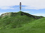
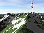
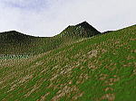
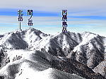
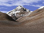
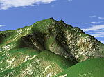
| This corner introduces result of 3D simulations of mountain view which is calculated by Kashmir 3D software designed by Mr. Dan Sugimoto, and also it presents real view which I have taken before to compare both. The Kashmir 3D software is a kind of free software. But, it has so many nice functions and I really surprised of it. To calculate a 3D mountain view, I also use a Digital Map 50m Grid (Elevation) issued by The Geographical Survey Institute which is a national surveying and mapping organization of the Ministry of Land, Infrastructure and Transport in Japan. |
| Kashmir 3D vs Real View |
| * To see more larger image, click your mouse on each thumnail. | |||
 |
 |
 |
 |
| Kurobegoro-Dake 2001.03.06 |
Tanigawa-Dake 2001.03.06 |
Amida-Dake 2001.03.07 |
Yariga-Take 2001.03.10 |
 |
 |
 |
 |
| Shirane-Sanzan 2001.03.11 |
Amida-Dake 2001.03.17 |
Utsugidake 2001.10.06 |
Tanigawadake 2002.07.14 |
 |
|||
| Mt. Fuji from the Airaraft 2003.04.12 |
|||
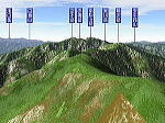
| Mountain Sectional Images by Kashmir 3D | |||||||||||||||||||||||||||||||||||||||||||||||||||||
| I tried to make a sectional image using the Kashmir 3D software. | |||||||||||||||||||||||||||||||||||||||||||||||||||||
|
|||||||||||||||||||||||||||||||||||||||||||||||||||||
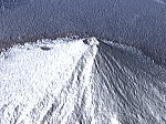
| Mountain 3D Movies by Kashmir 3D | |||||||||||||||||
| After making a movie file by Kashmir 3D,
a file has been changed into GIF image file so that a file can be easily decoded with browser software. * Need few minutes to download a file. |
|||||||||||||||||
|
|||||||||||||||||
| Back | ||||